10-28-21 HAWAII VOLCANOES UPDATES ~ real time data Kilauea 🌋 Mauna Loa 🌋 Leilani Geo ☢️ Fissures
Aloha PunaTics ❤️🔥❤️🔥❤️🔥

How has your week been? It’s been a busy week in the office here for me.
First off let me say- the next edition EPUB of Puna news weekly, won’t be released on Halloween as I expected LOL . Hey we’re on Island time here, gimme a break okurrrr ?! It WILL be released November 1st, and it will be delicious xo

It’s a cold night here in the farm.. windy… harvested lots of avocados and Mango today, and plan to harvest a load of breadfruit tomorrow, fresh Kukui nuts (and I mean LOTS OF KUKUI), and Mac nuts 🌰 .. 🌲 🌳 🥭 🍎 🍌 hope to get some banana soon and papaya one of these days before the animals get to it lol.. we have a really yummy seedless papaya tree… super old tree (yes they fruit year after year, I honestly don’t know why farmers choose to chop down after a harvest and start new but maybe there’s a reason ..)…and super delicious.
Sorry to blab your ear off.. YALL are the only thing I have to talk to lolol like for rizzle!
Heres KILAUEA UPDATE FOR TODAY XOXOX I’ll do a more detailed one in the morning with all the volcanoes and fissures as we have lots to talk about. Check back then .
Alert Level: WATCH, Color Code: ORANGE
HAWAIIAN VOLCANO OBSERVATORY DAILY UPDATE
U.S. Geological Survey
Thursday, October 28, 2021, 8:59 AM HST (Thursday, October 28, 2021, 18:59 UTC)
KILAUEA VOLCANO (VNUM #332010)
19°25'16" N 155°17'13" W, Summit Elevation 4091 ft (1247 m)
Current Volcano Alert Level: WATCH
Current Aviation Color Code: ORANGE
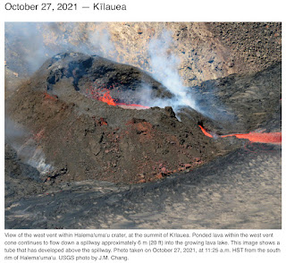
Activity Summary: Kīlauea volcano is erupting. As of this afternoon, October 27, 2021, lava continues to erupt from a single vent in the western wall of Halemaʻumaʻu crater. All lava activity is confined within Halemaʻumaʻu crater in Hawai‘i Volcanoes National Park. Seismic activity and volcanic gas emission rates remain elevated.
Summit Observations: Sulfur dioxide (SO2) emission rates remain high, with a preliminary emission rate for October 25, 2021, of at least 2,600 tonnes per day. No significant changes seen in summit tilt or GPS observations. Earthquake activity remains below background and volcanic tremor remains elevated since the beginning of the eruption.
Halemaʻumaʻu Lava Lake Observations: Lava continues to erupt from a single vent in the western wall of Halemaʻumaʻu crater. The western end of the lake showed a maximum elevation of approximately 794 meters (2605 ft) above sea level by HVO’s permanent laser rangefinder on October 27, 2021, which is 1 m (3 ft) higher than yesterday, and a total increase of about 50 meters (164 ft) since lava emerged on September 29. The total erupted volume since the beginning of the eruption was estimated to be about 19.9 million cubic meters (5.3 billion gallons) on October 15. Fountain heights at the western vent were typically less than 10 m (33 ft) high as observed by field crews on October 27, 2021. The lava lake is not level across its surface due to the location of the vent in the western end. There is about 8 meters (26 feet) elevation difference between the active west and stagnant east part of the lake as measured by field crews on October 25, 2021.
East Rift Zone Observations: No unusual activity has been noted in the Kīlauea East Rift Zone. Ground deformation measurements in the upper East Rift Zone area—between the summit and Puʻuʻōʻo—suggest that refilling of magma since late August, 2021 has slowed or decreased slightly. SO2 and hydrogen sulfide (H2S) emissions from Puʻuʻōʻō were below instrumental detection levels when last measured on January 7, 2021.
Hazard Analysis: This new eruption at Kīlauea’s summit is occurring within a closed area of Hawai'i Volcanoes National Park. Therefore, high levels of volcanic gas are the primary hazard of concern, as this hazard can have far-reaching effects down-wind. Large amounts of volcanic gas—primarily water vapor (H2O), carbon dioxide (CO2), and sulfur dioxide (SO2)—are continuously released during eruptions of Kīlauea Volcano. As SO2 is released from the summit, it reacts in the atmosphere to create the visible haze known as vog (volcanic smog) that has been observed downwind of Kīlauea. Vog creates the potential for airborne health hazards to residents and visitors, damages agricultural crops and other plants, and affects livestock. For more information on gas hazards at the summit of Kīlauea, please see: https://pubs.er.usgs.gov/publication/fs20173017. Vog information can be found at https://vog.ivhhn.org/.
Additional hazards include Pele's hair and other lightweight volcanic glass fragments from the lava fountains that will fall downwind of the fissure vents and dust the ground within a few hundred meters (yards) of the vent (s). Strong winds may waft lighter particles to greater distances. Residents should minimize exposure to these volcanic particles, which can cause skin and eye irritation.
Other significant hazards also remain around Kīlauea caldera from Halemaʻumaʻu crater wall instability, ground cracking, and rockfalls that can be enhanced by earthquakes within the area closed to the public. This underscores the extremely hazardous nature of Kīlauea caldera rim surrounding Halemaʻumaʻu crater, an area that has been closed to the public since early 2008.
For discussion of Kīlauea hazards, please see: https://www.usgs.gov/observatories/hawaiian-volcano-observatory/hazards
Please see the Hawaiʻi Volcanoes National Park website for visitor information: https://www.nps.gov/havo/index.htm. Visitors to Hawai'i Volcanoes National Park should note that under southerly (non-trade) wind conditions, there is potential for a dusting of powdery to gritty ash composed of volcanic glass and rock fragments. These ashfalls represent a minor hazard, but visitors should be aware that dustings of ash at areas around the Kīlauea summit are possible.
The Hawaiian Volcano Observatory (HVO) continues to closely monitor Kīlauea Volcano.
HVO will continue to issue daily Kīlauea Volcano updates until further notice. Additional messages will be issued as needed.
More Information:
Kīlauea activity summary also available by phone: (808) 967-8862
Kīlauea webcam images: https://www.usgs.gov/volcanoes/kilauea/webcams
Kīlauea photos/video: https://www.usgs.gov/volcanoes/kilauea/photo-video-chronology
Kīlauea lava-flow maps: https://www.usgs.gov/volcanoes/kilauea/maps
Kīlauea FAQs: https://www.usgs.gov/volcanoes/kilauea/faqs


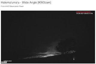
Here’s the a,along REAL TIME RIGHT NOW KILAUEA SUMMIT WEBCAMS 852pm 10-28-21 , enjoy (time stamp on webcam images from usgs)


HAWAIIAN VOLCANO OBSERVATORY WEEKLY UPDATE
U.S. Geological Survey
Thursday, October 28, 2021, 9:17 AM HST (Thursday, October 28, 2021, 19:17 UTC)
MAUNA LOA VOLCANO (VNUM #332020)
19°28'30" N 155°36'29" W, Summit Elevation 13681 ft (4170 m)
Current Volcano Alert Level: ADVISORY
Current Aviation Color Code: YELLOW
Activity Summary: Mauna Loa Volcano is not erupting. Rates of seismicity at the summit remain at long-term background levels. Other monitoring data streams—ground deformation, gas discharge, and visual observations—show no significant changes.
Observations:
During the past week, HVO seismometers recorded 94 small-magnitude earthquakes—all below M3.0—beneath the summit and upper-elevation flanks of Mauna Loa. The majority of these earthquakes occurred at shallow depths less than 10 kilometers (6 miles) below sea level.
Measurements of ground deformation, using Global Positioning System (GPS) instruments, confirm that the surface of the volcano has not moved significantly over the past week.
Gas concentrations and fumarole temperatures at both the summit caldera and at Sulphur Cone on the Southwest Rift Zone remain stable.
Webcam views have shown no changes to the landscape at the Mauna Loa summit or on the lower flanks of the volcano over the past week.
For more information on current monitoring of Mauna Loa Volcano, see: https://www.usgs.gov/volcanoes/mauna-loa/monitoring


Comments
Post a Comment