11/01/21 KILAUEA usgs update HAWAII VOLCANO ERUPTION
Hey guys, LERZ Puna News weekly ePub to be released 11/2/21 !

You can find these super awesome snapshots at https://www.usgs.gov/center-news/photo-and-video-chronology-k-lauea-november-1-2021


Leilani right now, real time data from usgs.com (more pics after update here xo keep reading )
Alert Level: WATCH, Color Code: ORANGE
2021-11-01 18:21:29
HAWAIIAN VOLCANO OBSERVATORY DAILY UPDATE
U.S. Geological Survey
Monday, November 1, 2021, 8:21 AM HST (Monday, November 1, 2021, 18:21 UTC)
KILAUEA VOLCANO (VNUM #332010)
19°25'16" N 155°17'13" W, Summit Elevation 4091 ft (1247 m)
Current Volcano Alert Level: WATCH
Current Aviation Color Code: ORANGE
Activity Summary: Kīlauea volcano is erupting. As of this morning, November 1, 2021, lava continues to erupt from a single vent in the western wall of Halemaʻumaʻu crater. All lava activity is confined within Halemaʻumaʻu crater in Hawai‘i Volcanoes National Park. Seismic activity and volcanic gas emission rates remain elevated.
Summit Observations: Sulfur dioxide (SO2) emission rates remain high, with a preliminary emission rate for October 28, 2021, of at least 3,600 tonnes per day. No significant changes seen in summit tilt or GPS observations. Earthquake activity remains below background and volcanic tremor remains elevated since the beginning of the eruption.
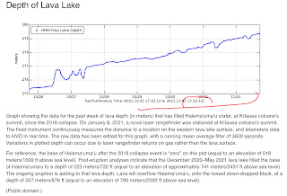
Halemaʻumaʻu Lava Lake Observations: Lava continues to erupt from a single vent in the western wall of Halemaʻumaʻu crater. The western end of the lake showed a maximum elevation of approximately 795 meters (2608 ft) above sea level by HVO’s permanent laser rangefinder on November 1, 2021, which is about the same as yesterday, and a total increase of about 51 meters (167 ft) since lava emerged on September 29. The total erupted volume since the beginning of the eruption was estimated to be about 19.9 million cubic meters (5.3 billion gallons) on October 15. Lava fountaining has been replaced by low roiling and spatter bursting at the western vent as observed by field crews on October 29, 2021. The lava lake is not level across its surface due to the location of the vent in the western end. There is about 8 meters (26 feet) elevation difference between the active west and stagnant east part of the lake as measured by field crews on October 27, 2021.
East Rift Zone Observations: No unusual activity has been noted in the Kīlauea East Rift Zone. Ground deformation measurements in the upper East Rift Zone area—between the summit and Puʻuʻōʻo—suggest that refilling of magma since late August, 2021 has slowed or decreased slightly. SO2 and hydrogen sulfide (H2S) emissions from Puʻuʻōʻō were below instrumental detection levels when last measured on January 7, 2021.
Hazard Analysis: This new eruption at Kīlauea’s summit is occurring within a closed area of Hawai'i Volcanoes National Park. Therefore, high levels of volcanic gas are the primary hazard of concern, as this hazard can have far-reaching effects down-wind. Large amounts of volcanic gas—primarily water vapor (H2O), carbon dioxide (CO2), and sulfur dioxide (SO2)—are continuously released during eruptions of Kīlauea Volcano. As SO2 is released from the summit, it reacts in the atmosphere to create the visible haze known as vog (volcanic smog) that has been observed downwind of Kīlauea. Vog creates the potential for airborne health hazards to residents and visitors, damages agricultural crops and other plants, and affects livestock. For more information on gas hazards at the summit of Kīlauea, please see: https://pubs.er.usgs.gov/publication/fs20173017. Vog information can be found at https://vog.ivhhn.org/.
Additional hazards include Pele's hair and other lightweight volcanic glass fragments from the lava fountains that will fall downwind of the fissure vents and dust the ground within a few hundred meters (yards) of the vent (s). Strong winds may waft lighter particles to greater distances. Residents should minimize exposure to these volcanic particles, which can cause skin and eye irritation.
Other significant hazards also remain around Kīlauea caldera from Halemaʻumaʻu crater wall instability, ground cracking, and rockfalls that can be enhanced by earthquakes within the area closed to the public. This underscores the extremely hazardous nature of Kīlauea caldera rim surrounding Halemaʻumaʻu crater, an area that has been closed to the public since early 2008.
For discussion of Kīlauea hazards, please see: https://www.usgs.gov/observatories/hawaiian-volcano-observatory/hazards
Please see the Hawaiʻi Volcanoes National Park website for visitor information: https://www.nps.gov/havo/index.htm. Visitors to Hawai'i Volcanoes National Park should note that under southerly (non-trade) wind conditions, there is potential for a dusting of powdery to gritty ash composed of volcanic glass and rock fragments. These ashfalls represent a minor hazard, but visitors should be aware that dustings of ash at areas around the Kīlauea summit are possible.
The Hawaiian Volcano Observatory (HVO) continues to closely monitor Kīlauea Volcano.
HVO will continue to issue daily Kīlauea Volcano updates until further notice. Additional messages will be issued as needed.
More Information:
Kīlauea activity summary also available by phone: (808) 967-8862
Kīlauea webcam images: https://www.usgs.gov/volcanoes/kilauea/webcams
Kīlauea photos/video: https://www.usgs.gov/volcanoes/kilauea/photo-video-chronology
Kīlauea lava-flow maps: https://www.usgs.gov/volcanoes/kilauea/maps
Kīlauea FAQs: https://www.usgs.gov/volcanoes/kilauea/faqs
----------
Subscribe to these messages: https://volcanoes.usgs.gov/vns2/
Summary of volcanic hazards from eruptions: https://www.usgs.gov/observatories/hawaiian-volcano-observatory/hazards
Recent earthquakes in Hawaiʻi (map and list): https://www.usgs.gov/observatories/hawaiian-volcano-observatory/earthquakes
Explanation of Volcano Alert Levels and Aviation Color Codes: https://www.usgs.gov/natural-hazards/volcano-hazards/about-alert-levels
CONTACT INFORMATION:
askHVO@usgs.gov
The Hawaiian Volcano Observatory is one of five volcano observatories within the U.S. Geological Survey and is responsible for monitoring volcanoes and earthquakes in Hawaiʻi.
K here’s the goods the right now the hello hi how are ya’s! Xo 📸
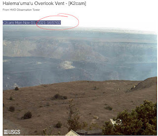
Enjoy the pics of the webcams at the summit :


Ohhh and here, the East rift zone AMAZINGMESS LOOK AT THESE SUNSET 🌅 WEBCAM REAL TIME CAPTURES

The beauty never ceases to amaze

The blessings from this planet are immeasurable


I hope y’all enjoyed this entry, and I hop they are bringing some monitoring to us in LERZ drill zones, I’m sick of being sick.
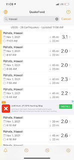
Here, take this for example, to add to the FALLACY lists : quake Monitoring. They have none ,and refuse to install any in the one and only area they know it’s needed, (by LEILANI ) PUNA GEOTHERMAL VENTURE 🙄 🧿 👁

This is just today alone . The images from quake feed show quakes all by the kumakahi point area, yet our local usgs HVO etc won’t tell us that on their sites. Why?


Here’s the technical kine tings


Aloooha.
Jazzy
Comments
Post a Comment